Maps are abstract depictions of the patterns one can observe in the field. A photograph is as close a representation one will likely have for that field observation, but a map must simplify that scene and apply consistent coding to each map unit. The increasing need to collect data across diverse landscapes, scales, and ownerships has resulted in a wider application of remote sensing, Geographic Information Systems (GIS), and associated geospatial technologies for natural resource applications. Key steps in preparing or using vegetation maps include defining user requirements for thematic and spatial resolutions, use of georeferenced sample data, mapping procedures, and assessing map accuracy. Here we provide background on commonly available vegetation-based maps, some methods used in their production, and examples of how map products may be used to address inventory needs of DoD.
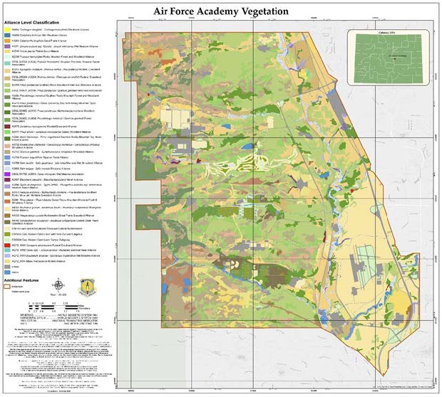
Thematic resolution refers to the conceptual detail of the classification unit being mapped. For example, using the USNVC, which is a multi-level classification, one might select a thematic resolution or mapping at the Macrogroup-, Group-, Alliance- or Association-level of classification, each describing an increasing degree of thematic detail. Figure 8.1 includes an example of mapping vegetation and land cover at the U.S. Air Force Academy, where vegetation types are mapped at Alliance- and Association-levels of the USNVC.
Importantly, the USNVC describes existing vegetation, with units spanning the continuum from apparently “natural” types (i.e., re-occurring plant species assemblages not apparently influenced by human actions) to “cultural” (e.g., lawns or farmlands planted and maintained by people). “Ruderal” classification units reflect vegetation falling in between, such as “old fields” that were previously converted lands and later abandoned. The plant species assembled in these areas have “no natural analog,” but neither do they require planting and maintenance.
Spatial resolution refers to the spatial detail depicted on the map. For maps generated to depict polygons, the “minimum map unit” (MMU), identifies the smallest polygon one will encounter in the map. Therefore, features that naturally occur in patches smaller than the MMU must be subsumed into adjacent or surrounding features. Aerial photographs are one primary source for producing polygon-based vegetation maps, and for local installation maps, the scale of the photos typically varies from 1:8,000 to 1:16,000, depending on the cameras used and the altitude of overflights. Aerial photography in the United States was systematically initiated in the late 1930s. Detailed polygon maps might reliably depict vegetation with MMU around 0.5 acre (2,023 m2).
Other maps are developed as rasters instead of polygons. Raster map layers are made of squares, or pixels, that depict type distributions. A common pixel size in vegetation-based mapping is 30 m. That is, each pixel represents an area on the ground of 30 m by 30 m (900 m2) in size. That size originates with the pixel size of images taken from cameras mounted on satellites. Beginning in the early 1970s, these earth observations from space have been gathered and data resulting from those observations are increasingly available for map making. In practice, vegetation maps generated using satellite imagery should not be considered reliable at 30 m pixel resolution. In fact, users should consider clusters of 30 m pixels between 5-10 acres (20,000-40,000 m2) in size as practical for using these types of maps.
Thematic and spatial resolutions in vegetation mapping interact primarily with the natural spatial character of a given vegetation type. Be it a 30 m pixel resolution or more detailed polygon coverage from aerial photos, vegetation types that occur as small patches and/or with an appearance that is difficult to distinguish from above will be difficult to map reliably using remote sensing. Therefore, map users need to be clear about their requirements for the vegetation maps they intend to create or use. One must match the opportunities and limitations of the map with the needs and available resources associated with the decision-making process they are intended to support. One must continually ask, “do I truly require a specific high thematic and spatial resolution, or can I make do with more coarsely scaled data?” If the decisions in need of support require more detail than available maps and mapping resources allow, field survey and documentation may be required.
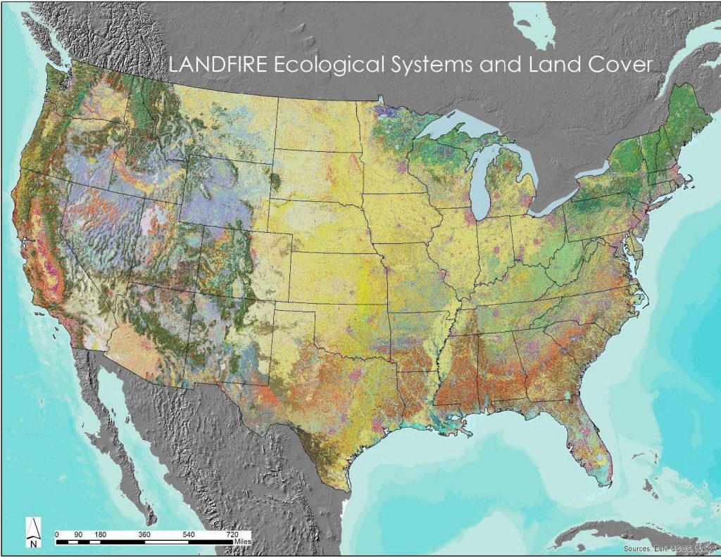
For national-scale mapping, current efforts such as with LANDFIRE, produce maps at the thematic resolution of NatureServe terrestrial ecological systems for existing vegetation type. The 2020 iteration of LANDFIRE, a second existing vegetation type map depicts the USNVC Group level for natural vegetation types.
LANDFIRE applied similar methods to develop maps of potential extent called Biophysical Setting (i.e., as types likely occurred with natural disturbance processes but without intensive human use impacts) (Rollins 2009). The main differences in the modeling approach are a) current satellite imagery was not used, as it depicts current patterns of land conversion or alteration, and b) fire dispersal and spread across different landscape settings was used to simulate historical fire effects and vegetation response (Figure 8.2).
Planning for landscape and ecosystem management
Planning decisions reflect resource management goals and objectives. They might stem from monitoring and evaluation of resources conditions, needs for changing land use designations, or determining appropriate resource uses.
Planning decisions typically fall into two categories: desired outcomes and allowable actions. Desired outcomes state goals and objectives for management that may be achieved within the planning time horizon. Allowable uses must identify the uses, or allocations, that are allowable, restricted, or prohibited in a given area. Management actions are the specific actions anticipated to achieve desired outcomes, including actions to maintain, restore, or improve land and water conditions. They may include specific actions or measurable criteria that will guide day-to-day activities.
Planning may encompass different geographic scales (e.g., regional vs. site specific) and timeframes (short-term vs. long-term), providing a comprehensive basis for implementing resource management actions. Planning at multiple scales may be necessary to resolve issues for a given area that is different from a plan defined for activity within the boundaries of a given DoD installation. For example, land use encroachment, invasive species, wildfire concerns, or ecosystem representation that cross jurisdictional boundaries may be assessed at broader scales, and then desired outcomes and management actions on the installation may be addressed in the context of that broader landscape.
Next Page: Box 8.2: Conserving rare and special status vegetation types
Author
Patrick Comer, Ph.D., Chief Ecologist
NatureServe
Managing Landscapes and Ecosystems
Managing Landscapes and Ecosystems
Box 8.2: Conserving rare and special status vegetation types