As planners focus on a specific conservation question to address in the INRMP, one of their first decisions is to determine the appropriate spatial scale for analysis. In order to create successful long-term strategies for protection or management, explicit consideration of biological and ecological patterns at different scales is important. Species differ in their size, mobility, physiology, and life history, and each responds to the same physical setting in different ways and at different scales (Addicott et al. 1987; Kotliar and Wiens 1990). Thus, the planning scale appropriate for one species is rarely fully appropriate for others.
Different species, communities, and ecological processes occur over different quantifiable spatial and temporal ranges, and as a result, each can be observed over a set of characteristic scales. Additionally, ecosystem threats, and effective methods and actions for alleviating them, also have characteristic scales at which they can and must be observed. Natural systems can experience threats to their continued function at many different geographic scales. Although specific threats to individual species or small groups of species often can be recognized, ranking the many biodiversity elements or ecosystem threats to determine priorities for conservation is a challenging, but necessary task.
Central to the ideals of conservation planning is that a method based explicitly in theories of conservation biology (e.g., redundancy, resilience, complementarity) that results in actions being taken to preserve biodiversity has a better chance of longterm success and is less biased than a purely ad hoc or reactionary approach (Margules and Pressey 2000, Groves 2003). However, the complex nature of ecosystems and their component biodiversity and integrative function (see O’Neill et al. 1986) makes conservation planning, at best, difficult. To simplify the problem such that it becomes manageable requires selecting a scale of analysis appropriate to the questions being asked and the mechanisms available for implementation.
The obvious patterns of scale perceived by the conservation planner rarely coincide with the spatial structure and configuration that drive the behavioral and ecosystem processes that are the subject of conservation efforts. For example, Poiani et al. (2000) proposed four spatial scale-levels to guide conservation planning efforts: regional (millions of hectares), coarse (tens of thousands to millions of hectares), intermediate (hundreds to tens of thousands of hectares), and local (hectares to thousands of hectares) (Figure 2.1).
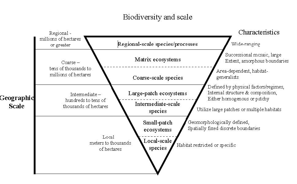
Figure 2.1. Biodiversity and scale interactions as envisioned by Poiani et al. (2000) produce four logical divisions for the purposes of conservation planning. Sanderson et al. (2002) suggested that “landscape species,” by merit of their extensive use of a landscape, capture the needs of many other species, and that planning for persistence of these would benefit conservation of many other species as well. Such planning frameworks, however, focus largely on the spatial extent of use, while ignoring the grain and pattern within a planning area. Andelman et al. (2000) reported that such “umbrella” species provide for the conservation needs of other species no better than do randomly selected species. This is a manifestation of the problematic issues of spatial scale.
Ideally, planning should be framed at a variety of scales. Using a hierarchical (nested) framework of scales not only ensures that a wide range of conservation targets and threats can be addressed, but also helps translate conservation priorities between scales, thereby providing larger-scale context to specific actions, while at the same time showing how fine-scale actions (e.g., actions on an installation) can contribute to coarse-scale (e.g., landscape or regional) conservation priorities. The conservation planner may be able to address only one question at one scale within the hierarchy at any one time, but must remain cognizant of its relationship to planning at other scales.
The choice of scale for a conservation plan is necessarily limited by the available data. The scale at which data are collected determines not only the detail at which features on the ground can be represented, but also the number of features that can be resolved. Both factors affect the inferences that can be drawn from spatial data (see discussion below). In most cases, the base data will consist of landcover and infrastructure, along with topographical data (elevation, slope, aspect). Which data sets are used will, in turn, depend upon the target of interest and the scale at which it responds to the environment (e.g., how species perceive their habitat).
Both natural and human-caused processes have characteristic frequencies and magnitudes that result in landscape patterns detectable only at certain scales. In this light, grain refers to the smallest elements upon which a process depends, and extent refers to the coarsest set of patterns a process produces (Addicott et al. 1987; Kotlair and Wiens 1990). For example, timber harvest typically has as its finest unit a forest stand which would define the grain of timber harvest, and the extent would be defined by the total area of harvestable forest land. Thus, from an ecological or management perspective, scale is tied directly to a specific process and is not an inherent property of a system (Wiens and Milne 1989). In other words, there is no one “ecological scale,” even for a single species, and a significant challenge in conservation planning is defining the right scales for assessing the effects of specific actions and ecological processes.